The Christina Gallery

On the Island of Martha’s Vineyard

  • Art
    • Artists
    • Original Paintings
    • Mini Boats
    • Modern Masters Collection
    • French Fashion Prints
    • Botanicals
    • Sailors Valentines
    • Burgees
    • Hand Colored Engravings
    • Watercolors
    • Prints
  • Maps
    • Cartographers
    • Massachusetts
    • New England
    • New York
    • World Maps
    • All Map Areas
  • On Sale
    • Original Paintings
    • Modern Masters Collection
    • Maps on Sale
    • Nautical Charts on Sale
    • Limited Edition Prints

The Christina Gallery

  • Tour
  • News & Blog
  • About
Virginiae et Floridae 1650

Virginiae et Floridae 1650

by Willem Blaeu (1571-1638)
Original Antique Map, 29" x 33" Framed, $4,200
Purchase Now

Include shipping information if different from the billing information above.

After you send this purchase request for “Virginiae et Floridae 1650” the gallery will prepare an invoice and send it to you by email.

Enquire about this piece

The details about “Virginiae et Floridae 1650” will be included in your message automatically, there is no need to repeat them.

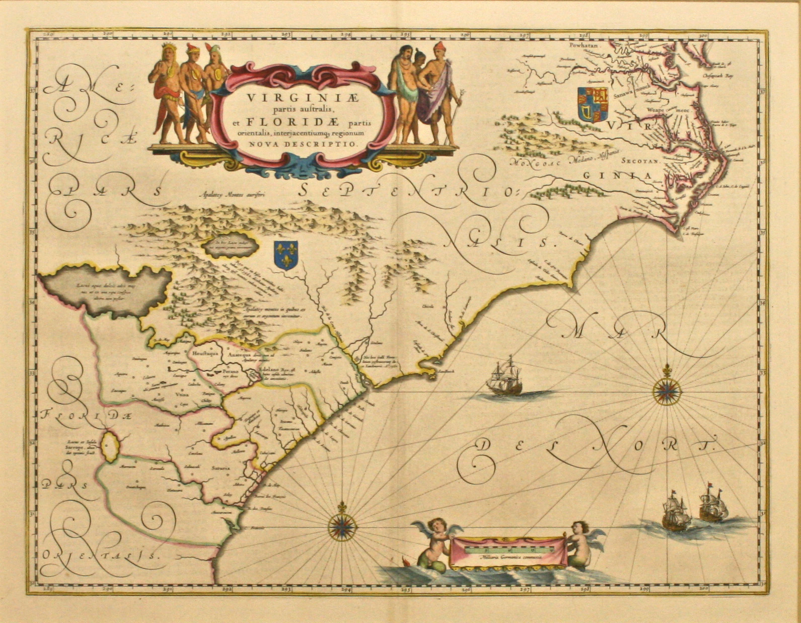
This original map of Virginiae et Floridae, dated 1650, (full title: Virginiae Partis Australis, et Floridae Partis Orientalis, Interjacentiumq Regionum Nova Descriptio) is by Willem Blaeu (1571 – 1683). The map is from the 1650 latin text edition of Theatrum Orbis Terrarum, sive, Atlas Novus. The map is the second state as noted by the cherub with “tail” to the left of the scale and the incorrect longitude sequence in the lower right (298, 299, 200). The map covers the area known today as the Chesapeake Bay south to northern Florida. The area was of interest to the French and the English as noted by their respective coat of arms. The mentioning of Newport nesa (Newport News, founded in 1621) is significant as it apparently is the first time featured on a map. At the southern end of the Appalachians is a note concerning gold and silver mines. In the upper portion of the map is a lavish cartouche flanked by Native Americans. The Atlantic Ocean contains two compass roses and three sailing ships. The framing is done to conservation standards with hand-wrapped silk mat and carved gold frame.

Original Antique Map by Willem Blaeu

Virginiae et Floridae 1650


The Christina Gallery

The Christina Gallery
5 Winter Street
Edgartown MA 02539
508-627-8794
art@christina.com

  • Facebook
  • Instagram
  • RSS
Sign up for our newsletter!

Header Image
Le Plan de Paris
Copyright 2025 The Christina Gallery Technology by Tenseg