The Christina Gallery
On the Island of Martha’s Vineyard
Art
Artists
Original Paintings
Mini Boats
Modern Masters Collection
French Fashion Prints
Botanicals
Sailors Valentines
Burgees
Hand Colored Engravings
Watercolors
Prints
Maps
Cartographers
Massachusetts
New England
New York
World Maps
All Map Areas
On Sale
Original Paintings
Modern Masters Collection
Maps on Sale
Nautical Charts on Sale
Limited Edition Prints
The Christina Gallery
Tour
News & Blog
About
United States
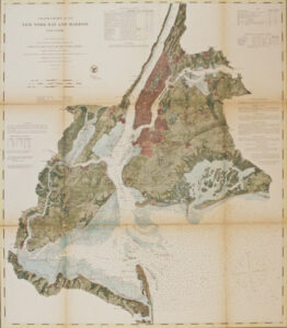
New York Bay & Harbor 1866
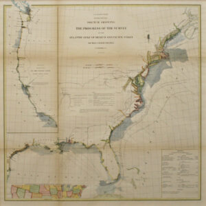
Atlantic, Gulf of Mexico & Pacific Coast 1871